Innovative techniques of organic and mineral fertilization in soil context vulnerable to compaction
In pedological contexts vulnerable to compaction, joined with traditional agronomic technique may degrade the soil structure and therefore the yields.
The difficulty of planning field activities and the fragility of such soils represent the two main limiting factors.
A more efficient distribution of organic and mineral fertilisers and the improvement of the soil structure, represent the main objectives of the SmartFIT project.
The three different strategies were identified:
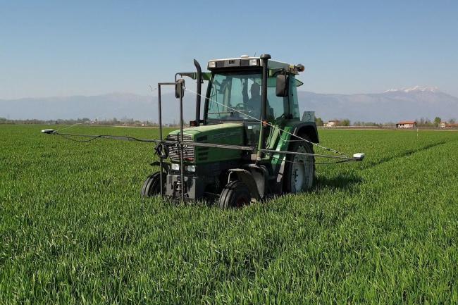
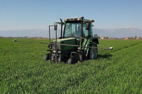
- Georeferenced and differenced distribution of chemical and organic input;
- Optimisation of transit lines of the farm machines;
- Assessment of the optimal moment of field intervention.
The activities developed during the project aim to work on farms with hard soil conditions and are divided by WP, as follow:
WP1 – Project management: OG Organization;
WP2 – Project information and dissemination: share project results with other farmer managers;
WP3 – Data collection and pre-elaboration: Big data management, soil, biomass and vegetative index;
WP4 – Distribution of nutritious elements: conventional and Variable rate application comparison;
WP5 – Soil transitability: transit lines cheking and moment of field intervention;
WP6 – Decision Support System (DSS) that have to help the farmer decision;
WP7 – Summary and project replicability
Agrinnovation: the first social network dedicated to agriculture
Welcome to Agrinnovation! This is the first social network dedicated to innovation in Agriculture! Companies, consultants, economic operators, and professional organizations will have the opportunity to get in touch, share information, news and innovations in the field of agriculture and forestry. To log in please use the following link and sign up: www.agrinnovation.it
How does Agrinnovation work?
PERSONAL PROFILE
As in a common social network there is the possibility to create a personal profile and upload photos, video, post, in the field of agriculture. The main aim is to connect and share experience with other users. Agrinnovation is not just for workers but also for students and agriculture lovers.
SPACES
The “spaces” in Agrinnovation are virtual groups used for sharing information of innovative projects, good practice, promote farms or just as a virtual discussion. Each user are able to find spaces by using keywords or create a new one.
A novel method of publishing post is the possibility to use of “wiki module” to generate more elaborate posts and upload files to download. A direct post sharing versus other social networks (Facebook, Twitter and Linkedin) is allowed by using the specific bottons positioned below the post. In addiction is it possible to download the “Agrinnovation” app by searching it on the play store.
How to map the soil variability?
With the aim of testing the precision agriculture, controlled traffic farming, and estimate the best moment to enter into the field is it important to acquire geo-spatial soil information.
A novel approach to soil mapping has beed used. The traditional soil samples are driven by geo-eletric sensor ables to identify different soil zones.
Geoelettric analysis
The geo-elettric analysis is operated by using a sled pulled by a tractor, able to emit electric pulses at different soil depth. In function of the different electric conuctivity is it possible to identify different soil zones.
Soil sampling
The mail aim of the soil sampling is to provide a chimical, phisical and pedological soil analysis. For each study area, around 20 ha, 18 superficial sampling point have beed collected (with 5 sub-sample for each sample between 0 and 30 cm of soil depth) for the lab analysis and other 18 soil drillings (at 120 cm soil depth) to identify the soil type. Finally two depth drilling (at 150 cm soil depth) to know the soil horizonts. For each soil layer identifyed, has been collected a sample to have a whole soil knowledge that will be a support for the farmer decisions.
| Titolo/Descrizione | Url | Tipologia |
|---|---|---|
|
Sito web del progetto
|
Sito web
|
|
|
Facebook
|
Link ad altri siti che ospitano informazioni del progetto
|
|
|
TESAF - UNIPD
|
Link ad altri siti che ospitano informazioni del progetto
|
|
|
ERAPRA
|
Link ad altri siti che ospitano informazioni del progetto
|
|
|
Confagricoltura Treviso
|
Link ad altri siti che ospitano informazioni del progetto
|
|
|
Agrinnovation
|
Link ad altri siti che ospitano informazioni del progetto
|
|
|
Article - Padovanews - Agriculture and soil protection in the SMARTFIT project
|
Materiali utili
|
|
|
Youtube channel
|
Materiali utili
|